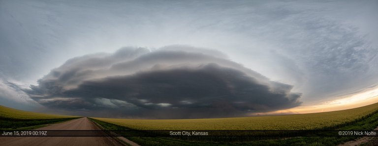
Blog

26 May

May 26, 2017 – Eastern Colorado

May 26th and 27th looked like a couple of opportunities for some storm chasing in the High Plains. The 26th looked like a decent upslope shot in Eastern Colorado while the following day looked much more potent, but looked like it could transpire across unfavorable chasing terrain in Eastern Kansas, Northeast Oklahoma and Southern Missouri.

Read more
18 May

May 18, 2017 – High Risk Bust in Kansas

May 18th presented the first high risk in the Central Kansas region in five years. At the surface, a low pressure over southeastern Colorado was forecast to drift east along a warm front through Central Kansas while a dryline sharpened throughout the day from Western Kansas down into Texas. Rich moisture was streaming north across the target area with 70°F dewpoints in Texas and mid to upper 60°F dewpoints into Kansas. Very favorable low level shear was present along the frontal zones as well as across the warm sector setting the stage for a possible significant outbreak of severe weather.

Read more
16 May

May 16, 2017 – Susank, Kansas Tornado

May 16th featured a deep trough over New Mexico with a lead shortwave that was expected to overspread the Central and Southern Plains during the afternoon. Mid to upper 60° dewpoints were streaming north into the Texas Panhandle and Western Oklahoma which would lend to afternoon MLCAPE values exceeding 3,000 J/Kg. While much of area along the dryline was forecast for severe weather, there was an enhanced pocket of low level shear along the Texas Panhandle/Oklahoma border which earned a moderate risk from the SPC with 15% hatched tornado probabilities at the 1630z update.

Read more
15 Apr

April 15, 2017 – Coldwater, Kansas Supercell

April 15th featured mostly westerly flow at 500mb across the Central Plains while a cold front was expected to migrate southward through Kansas. The intersection of this and a dryline was the focal point for severe weather for this day. The initial 13z SPC outlook placed a 2% tornado risk along the dryline from Dodge City to Childress, but was later upgraded to an extremely small 5% area centered near Woodward at the triple point. This seemed to be the obvious play for the day, but capping was a concern throughout.

Read more
14 Apr

April 14, 2017 – Central Nebraska

Generally westerly flow aloft as a trough edged in from the Pacific Northwest while at the surface a surface low was progged to develop in NE Colorado and drift eastward while a dryline extended south through Western Kansas into New Mexico. SPC had outlined a slight risk along the dryline from Kansas south along the Texas/New Mexico border. Marginal tornado probabilities extended along the same region as well as a bit into Nebraska closer to the low.

Read more