Month: June 2010

27 Jun

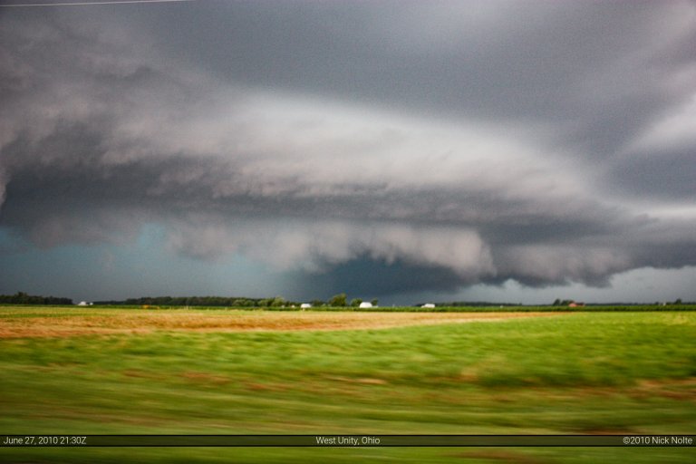
June 27, 2010 – Northwest Ohio

Well, this day had setup to look like a good one, but it turned out to be rather mediocre.  I actually chased twice today since most of the action was within the vicinity of my house.  I went after the original MCS that was coming across Lower Michigan in the morning.  I thought it would hold together and I could get some nice squall line/shelf cloud shots, but it weakened pretty rapidly.  At the same time, while I was down in Coldwater, storms had developed over Calhoun County and moved, pretty much over my house.  Another cell popped up in Washtenaw County that went tornado warned.  I tried to catch up to them, but once I got back close to home I figured there was no way to make it before they crossed into Canada or went over the lake.

Read more
23 Jun

June 23, 2010 – Northern Indiana Derecho

I was anticipating some pretty decent severe weather across central Lower Michigan.  This did not pan out at all.  I ended up heading just across the border into Indiana to at least catch the derecho that was heading east so the day wouldn’t be a complete loss.  I sat around home in Grass Lake, MI until about 1pm before I decided to go out.  Although the SPC had trimmed back the moderate risk to exclude most of mid-Michigan, the ingredients still looked pretty good.  The worrisome thing was the cloud shield left over from the MCS that cruised through in the early morning around 10am.  However, there was some clearing in Wisconsin and across Lake Michigan, so hopefully that’d propagate into Michigan.  I had figured everything in Illinois and Indiana would go linear and develop into a derecho as the day progressed and I figured central Michigan was the best chance for isolated storms.Read more

18 Jun

June 18, 2010 – Southeast Iowa

Just before I left Michigan I decided to forego my original target in southwestern Wisconsin because I figured the MCS that was ongoing was going to preclude any discrete cells.  Apparently that was the case as there were only two tornado reports one in Madison County, IA and the other southeast of the Quad Cities.  It turned out to be a major wind event as several lines of storms marched across the area.  I ran into one line northeast of Peoria, IL on my way to southeast Iowa as I was going to see if I could get in on the southern action.  In the photo below, as the line came over that hill it was kicking up some major dust.Read more

05 Jun

June 5, 2010 – Elmwood, IL Tornado

The night of the 4th had forecast models drawing a picture of a decent severe weather outbreak across central Iowa, Illinois and Indiana.  I debated whether or not to expend the energy to chase this situation, but being so close to home I had to.  When the morning rolled around the SPC had drawn out a moderate risk area across eastern Iowa, north central Illinois and Indiana and into Ohio.  After checking the models and the surface conditions from the 12Z observations, I decided this day might just be worth doing and headed out of town here in Michigan at 10am hoping to reach western Illinois by 3pm EDT.

Read more