Month: May 2013

31 May

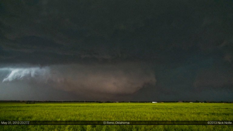
May 31, 2013 – The El Reno EF-5

My first real storm chase was May 10, 2010. I had decided that winter to read everything I could about severe weather and figured I’d give it a shot on my own. In retrospect, it may have been a better idea to learn from someone with experience, but nevertheless I jumped in feet first and on my first storm chase caught the tornado near Wakita, Oklahoma. I still remember standing outside my car on Oklahoma Route 11a about 1.25 miles north of highway 11 watching this spinning bowl spawn vortex after vortex in the distance. It took me longer than I’d like to admit to realize that tornado was headed right for where I was standing. I still remember turning east onto highway 11 as the winds picked up and wind driven rain was blasting my car. After the fact, I realized this was probably the rear flanking downdraft, but at the time I wasn’t sure. My adrenaline was pumping and I was very anxious to get the hell out of there. Traffic on the highway wasn’t helping with my planned expedient escape. Eventually, the wind subsided as the trail of cars progressed east and the tornado carried on to our north. I still remember the first time I stopped after the escape and my hands were shaking, probably a mix of adrenaline and gripping the steering wheel, but I was on edge after that. Since that day in Grant County, I’ve been on over 100 storm chases and I haven’t been that nervous on any of them until El Reno.

Read more
30 May

May 30, 2013 – Cushing, Oklahoma Tornado

A negatively tilted trough continued it’s eastward march and while it’s strongest winds were displaced to the northeast from the target area, convective outflow from the previous night’s storms and an eastward mixing dryline would help foster convective development across Oklahoma. The trick would be our upper support would be moving out of the area and heights would be rising. Would the instability be able to overcome this? SPC seemed to think the possibility was there and it warranted a 10% hatched moderate tornado risk for the day.

Read more
29 May

May 29, 2013 – Western Kansas

The 29th through 31st was a decent looking setup, enough to draw me out from Michigan into the Plains for a go. A negatively tilted trough positioned over the high plains was expected to eject out across the Plains for the next few days. Stronger bands of H5 winds were expected along the dryline from southwestern Nebraska into western Oklahoma. A strengthening surface low in southwest Kansas would help back winds across the warm sector and in the vicinity of the dryline. A nocturnal low level jet was progged to strengthen and would cause increased tornadic potential for any storms that could push off the dryline.

Read more
20 May

May 20, 2013 – Missing Moore

Today was the final chase day of a four day excursion which included some beautiful tornadoes near Rozel followed by a couple frustrating chase days.  The 19th proved to be a rough day as we may have squeaked out two tornadoes, but nothing terribly photogenic. We awoke the day in Okmulgee after the hairy chase the prior day and knew we were probably going to be heading southwest towards OKC, maybe even south of there. We took off from Okmulgee just before noon and made the trek westward on I-40.

Read more
19 May

May 19, 2013 – Welty, Oklahoma Tornado

Chased, again, with Jonathan Williamson, Jeremy Degenhart and Alec Scholten. We stayed in Emporia the night before and our target area for the day was somewhere along the KS/OK border east of I-35, including the dreaded Osage County. Nevertheless, we were ready to roll and departed the hotel around 11am and bolted down the turnpike. We were originally watching a remnant outflow boundary that was drifting north as a possible area for initiation and increased tornadic potential. As we continued south it became harder and harder to see that boundary on satellite so we turned to watching for subtle wind shifts in the METAR data.

Read more