Month: May 2015

25 May

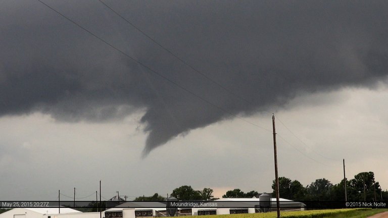
May 25, 2015 – Central Kansas

May 25th was the final day of my three day mini chasecation and I had spent the night in Hays expecting a play in Central Kansas. A negatively tilted mid level trough was expected to rotate out of the foothills and into the Missouri Valley while modest meridonal flow of 80-100kts overspread the target areas. The SPC had outlined two risk areas: A moderate risk of severe weather in Eastern Texas as well as a slight risk from Salina to Des Moines along a frontal zone where higher lapse rates were expected to overspread mid to upper 60s surface dewpoints later in the day.

Read more
24 May

May 24, 2015 – Still in Colorado!

Day two of a three day chase featured a slight risk in the Ozarks while marginal severe probabilities existed on the High Plains. A weak surface low was forecast to develop near the panhandle region and move north eventually consolidating near the Nebraska/Kansas border. With a negatively tilted trough and 100kt upper jet there was a decent chance for severe weather in Eastern Colorado into Western Kansas where dewpoints were progged to reach the low to mid 50s.

Read more
23 May

May 23, 2015 – Eastern Colorado

Day one of a three day mini-chasecation as a upper trough was expected to eject into the Plains potentially providing three days of severe weather. The 23rd presented two target areas: Western Texas and Western Oklahoma was characterized by moderate deep layer shear and modest instability while a second target area in Eastern Colorado where a decent area of instability was expected to develop northeast of the surface low, backing low level winds and advecting 50°F dewpoints into the area.

Read more
16 May

May 16, 2015 – Elmer, Oklahoma Tornado

May 16th was the second day of a three day chase. Today a negatively tilted trough was expected to eject over The Plains with a 100kt upper jet poking into the target area. A low pressure in Colorado was progged to shift eastward into Nebraska during the day while a trailing cold front and dryline were expected to surge east across the Texas Panhandle into Oklahoma.

Read more
15 May

May 15, 2015 – Sidney, Nebraska

May 15th and 16th presented a couple of elevated days for severe weather. Despite them probably setting up in Western Nebraska and Southwest Oklahoma/Texas Panhandle area, I decided to make the trek out for the two days. A large trough was working its way through the western CONUS while a weak surface low worked its way across the High Plains into Nebraska. This low would bring with it the enhanced risk for severe weather along a warm front extending across Southern Nebraska as well as along a trailing dryline. Backed low level flow near the low would be the target area.

Read more