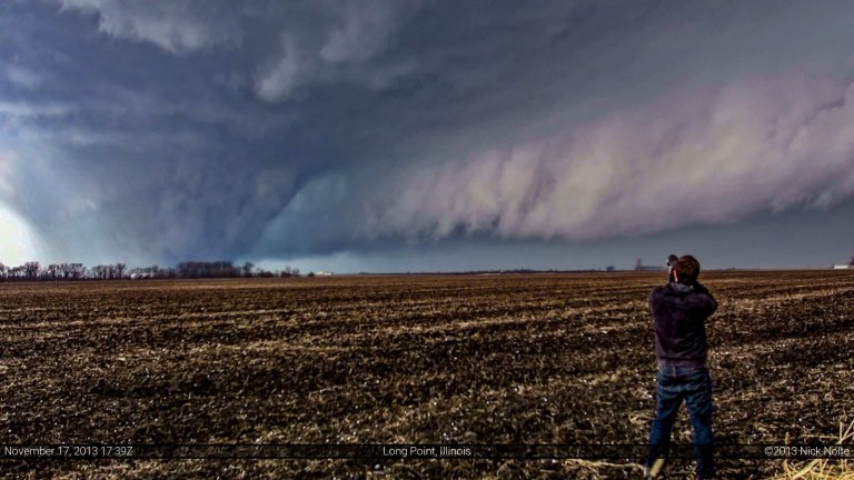
Blog

02 Jun

June 2, 2011 – Beautiful South Dakota

Ah, to be in South Dakota again! A strong trough was expected to move from the Rockies to the Northern Plains which would nudge the cold front eastward across the western Dakotas providing focus for storms to my north. Meanwhile a warm front draped from North Dakota down into Iowa and Missouri would provide a focus for storms to my east.  I opted to play the cold front as the warm sector would be flooded with ML CAPE near the 4,000 J/Kg range along with strong low level winds and curved hodographs would set the stage for a potentially decent severe weather threat.

Read more
01 Jun

June 1, 2011 – Stockton, Kansas

Convergence along a lee trough was expected to trigger scattered thunderstorms from New Mexico to Nebraska.  Southwesterly flow from 500mb up juxtaposed over southerly flow in the low levels would create an environment supportive of supercells while the large CAPE would promote large hail while large low level shear and high helicity would promote possible tornadic activity.  I awoke in Sioux Falls, SD and wished I had at least driven a little south the day before, but I spent the 31st resting and relaxing.  Anyway, I left Sioux Falls at 1340z and made my way down to my target area of Norton, KS.

Read more
30 May

May 30, 2011 – O’Neill, Nebraska

As I was about to check in to my hotel the night before this day, the front desk clerk informed me that she needed to go break up a fight. She then proceeded out the front door and began yelling at someone. A few minutes later she came back in and mentioned she would need to call the police. And so began a great stay at the Rodeway Inn in Grand Island, Nebraska.

Anyway, loud air conditioners and crappy wifi aside, we would begin the following morning feeling pretty good about our location. For the start of the day I chased with Brandon Sullivan, Connor McCrorey, Evan Bookbinder, Scott Bennett, Robin Lorenson and a few others.

Read more
29 May

May 29, 2011 – The Lincoln “Super”cell

Another one of those marginal setup days.  A dryline draped across Nebraska, Kansas, Oklahoma into Texas was supposed to become a bit more defined during the day and push eastward providing potential focus for isolated thunderstorm development. The question mark was how long storms would live once they pushed off the dryline, as the warm sector was pretty well capped. That would be a question we would see answered in spectacular fashion.

Read more
28 May

May 28, 2011 – Colorado Upslope Attempt

This would be my first attempt at chasing upslope in Colorado.  Admittedly, my knowledge in this area is very lacking.  While I’d read up on things like the Denver Convergence and Vorticity Zone, what I knew beyond that, as far as Colorado orographics goes, was limited at best.  The previous day, sweating my ass off in Southwestern Oklahoma, I noticed forecast models showing southeasterly surface winds in Colorado and figured, hey this might be a good opportunity to go after that 2% colorado tornado threat.

Read more