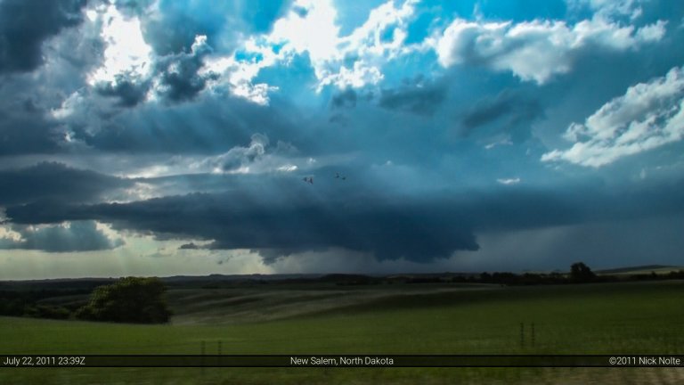
Blog

19 May

May 19, 2011 – Kansas

Kansas dryline play. Mid 60 dewpoints were expected to advect into southern Kansas while a well defined dryline would provide the focus for thunderstorm development. As the low level wind fields increased, the possibility for tornadoes were on the rise. The big issue with the day was the possible lack of forcing as much of the mid and upper level air support was slightly shunted west of the dryline. The only real hope for the day was that the dryline would be enough forcing by itself and hope that low level shear would ramp up once the LLJ kicked in.

Read more
26 Apr

April 26, 2011 – Michigan

Hadn’t really paid attention to this day in Michigan. The big story was the impending tornado outbreak for the southeast that was to start this evening. Nevertheless, a little after 1pm a mesoscale discussion was issued regarding the potential for severe weather across Lower Michigan. A surface low near Green Bay had a trailing cold front back through lower Michigan into Illinois. This front was expected to trigger storms as the atmosphere destabilized. Strong boundary layer flow coupled with strong flow at the mid levels was conducive to supercellular development.

Read more
22 Apr

April 22, 2011 – St. Louis, Missouri

A surface low was expected to swing through Missouri with an attendant warm front draped across Missouri, Illinois and Indiana, as well as a trailing cold front extending back into Oklahoma.  The question was whether or not there would be a decent shot at tornadic storms.  The SPC had placed a large 5% tornado risk across southern Missouri, Illinois and Indiana.   I took off from home around 8am in the morning.  As I got closer and closer to Missouri, the visible satellite was showing a pronounced clearing across the bottom of the state along and south of I-70. It became clear that the greatest destabilization would occur in this area.

Read more
19 Apr

April 19, 2011 – Girard, IL EF-3 Tornado

For a day or three prior, April 19th was looking like a decent shot at severe weather along the warm front and near a surface low that was expected to be in Southwest Illinois.  The SPC had outlined the area in a moderate risk and had a 10% tornado outline for Southeast Missouri, Southern Illinois and Southern Indiana.  The Indiana portion would be for after sunset, so that wasn’t considered in the selection of a target.

Read more
09 Apr

Mesonet Data From Mapleton, Iowa Tornado – April 9, 2011

First, let me preface this with the following: my homemade instrumentation is by no means intended as a substitute for scientific grade research equipment. I certainly did not go out and spend thousands of dollars on research grade equipment, nor did I spend hours and money on scientific calibration techniques. What I did is collect a bunch of decent sensors which had decent specifications befitting of someone who wanted to collect data in the field and check it out later. Before taking it out in the field, I compared it with ASOS readings nearby and was usually within a degree on temperature, a percent or two on humidity and 1 hPa on pressure. I considered that good enough for my purposes. You can review the parts I’ve selected for my measurements in my mesonet build project posts earlier on this blog.

Read more