Blog

07 May

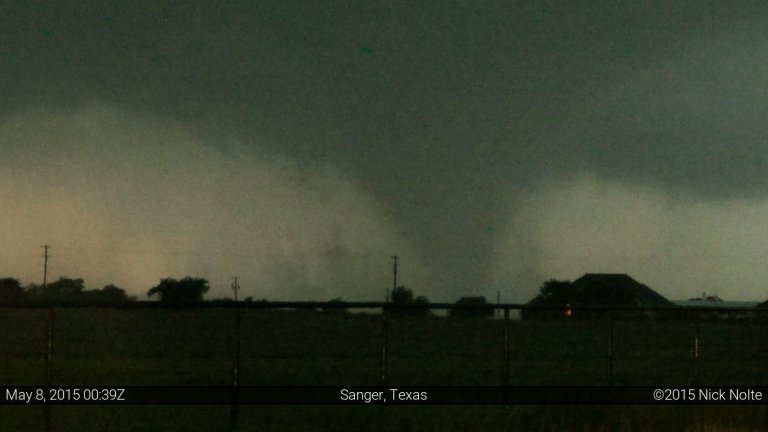
May 7, 2015 – Sanger, Texas Tornado

Thursday, May 7th was the start of a four day chase event starting in the Southern Plains and moving north each day into the Northern Plains on the 10th as a pretty deep 500mb trough was making it’s way onshore from the Pacific through the four corners region and into the Dakotas. Each day would present itself with a severe weather opportunity. The first day being focused along the Red River area along the Oklahoma/Texas border as well as further upslope in the SW KS/OK Panhandle areas where dryline intersected a cold front. Overnight convection was still ongoing across southern and eastern Oklahoma at daybreak and while upper level energy was still quite a ways west, I felt that the outflow from the overnight MCS might be the focus area for the day and set my target for Wichita Falls.

Read more
25 Apr

April 25, 2015 – Illinois

April 25th was the second day of a little mini chase weekend and a shortwave trough was moving east into the Ohio Valley while it deamplified a bit. That was coupled with the nose of a 130kt jet streak at 250mb and a sub-1000mb surface low that was progged to drift east throughout the day. The plan was to play in Southern Illinois just east of St. Louis where a clear slot was expected to form allowing for modest instability to develop and hope for storms to develop and ride the front.

Read more
24 Apr

April 24, 2015 – Kansas

April 24th and 25th presented a couple of opportunities for severe weather across the Great Plains and lower Ohio Valley, so I left Michigan on the 23rd and overnighted in Cameron, MO. Cameron has become my goto town for sleeping if I’m heading out to chase the Plains and leave the evening before. Anyway, the 24th presented two targets for chasers. The first target area was Central Kansas where a surface low and slow moving warm front provided a focus for severe weather. The second was Eastern Texas where a warm front/outflow boundary was being intersected by a rapidly advancing dryline. Both areas were delineated in an enhanced risk from the Storm Prediction Center, although the Texas play had higher tornado probabilities.

Read more
09 Apr

April 9, 2015 – Iowa / Illinois

The day began in Cameron, Missouri and our preliminary forecast was looking at the eastern portion of Iowa for supercells early on in the afternoon. A low pressure that was centered over eastern Nebraska was progged to move eastward dragging a trailing cold front along with it. To the east of the surface low a warm front across Iowa and northern Illinois was the focus of our chase for the day and we expected to play just east of the triple point.

Read more
12 Apr

Using QGIS to map your travels

I know some of us are familiar with the county tracking website where we log all the counties we’ve visited and generate a map of where we’ve been. I even have my own map there, but I haven’t updated it in a couple of years. The user input on that website relies on you manually clicking on whichever counties you want to log as visited. Many of us like statistics, and we like to track where we’ve been. As a GIS Analyst, I love maps. I love mapping data and analyzing that data on maps as well. I thought I could do a post (or a series of posts) on using GIS to generate maps from our storm chasing shenanigans.

Read more