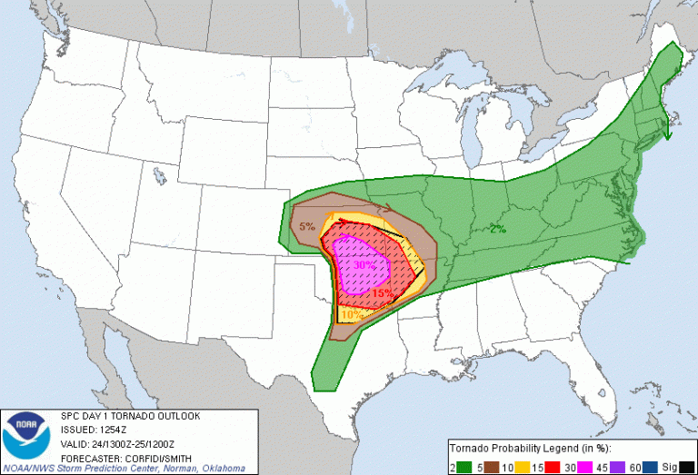
Blog

25 May

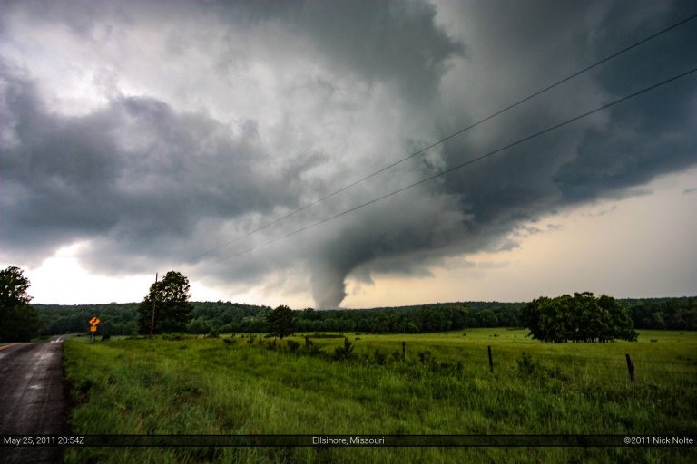
May 25, 2011 – Ellsinore, Missouri Tornado

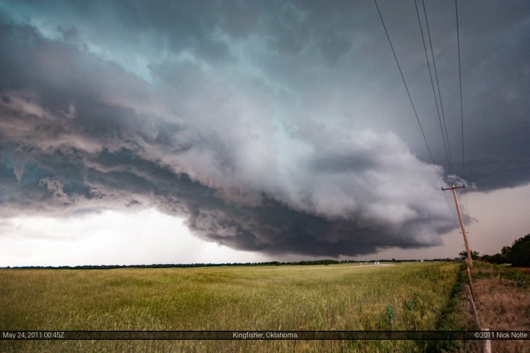
Day 2 of back to back high risks from the SPC.  After our bust in Oklahoma the previous day, I was solo this day.  I awoke in Springfield, Missouri and my early morning forecast dictated that I needed to move east a bit.  Winona, MO was my original target as it had several road options.

Storms were already firing ahead of the front as I drove east on US-60.  I figured with quick storm motions I would need to get east to give any discrete cells time to develop.  After sitting in Winona for a bit I decided to head north to Salem to attempt to get a look at a tornado warned cell in that vicinity.  As I approached town the cells to the north had started to become less discrete.  It was at this time I decided to head back south to a better environment and where cells that were firing were remaining separate.

Read more
24 May

May 24, 2011 – Oklahoma High Risk Bust

Ah, one of those days where if you could do it all over again, you would. We spent the night in Wichita and awoke to a high risk outlook from the SPC from Wichita down to Sulphur and places east, including a 30% hatched probability for tornadoes. One of the psychological problems I have with high risk days is I think people get into the mindset that you won’t be able to take a step without running into a tornado. SPC issues a high risk and just being in the area guarantees you a tornado, right? Yeah, storm chasing isn’t that easy lol. Anyway, just a warning, there is no photos or video from this day since we busted hard, but feel free to read along and revel in our misery…

Read more
23 May

May 23, 2011 – West Central Oklahoma

May 23 was a day before the day event. SPC had a day 2 moderate for the 24th and with the 13z update, upgraded the 23rd to MDT as well. We concluded the chase yesterday in Tulsa, A trough digging in from the west was expected to amplify as upper energy moved onshore west of Baja, this was going to be the focus for the outbreak on the 24th/25th. However, another day of strong heating coupled with a diffuse boundary draped across the OK/KS border and some relatively strong LLJ expected later, we figured there would be action in west central Oklahoma, so we left Wichita shortly after lunch and made our way through OKC and westward on I-40.

Read more
22 May

May 22, 2011 – Northeastern Oklahoma

After a mind-blowing day in Oklahoma we hung around Ada for the majority of the 22nd expecting the atmosphere to reload and provide a show, perhaps slightly northeast of the 21st.  We hung around the hotel parking lot in Ada chatting with fellow chaser Nathan Edwards as we sat under the blistering sun.  It was looking like a day where storms would erupt along the cold front/dryline from Wisconsin all the way into Texas.  We were concerned about the cap holding towards the Red River and figured further north was the play.

Read more
21 May

May 21, 2011 – Central Oklahoma Tornadofest

I was chasing with Rob Hurkes and James Seitz from Minnesota these few days.  Our target this day was Purcell, Oklahoma. We departed from Wichita, KS at 1523z and began our trek down I-35. In similar fashion to the day before, a pacific front/dryline was expected to be the trigger for storms in eastern Kansas and Oklahoma. The threat for tornadoes would increase as the day wore on and the LLJ kicked in. After sitting in Purcell for two hours we started to get restless and moved east towards Asher as the dryline advanced. After twenty more minutes in Asher we moved north to Tecumseh in an effort to position ourselves to the northeast of the dryline bulge we were seeing on KTLX. After an hour went by we decided to head back south to the cumulus field that started to present itself on visible satellite. Shortly after 23Z storms began to develop south of Ardmore. The show was starting.

Read more