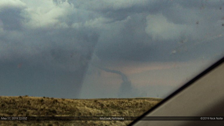
Blog

13 Aug

August 13, 2017 – Broken Bow, Nebraska

August 13th featured a shortwave impulse moving across the Northern Plains with a weak surface low over South Dakota slowly drifting east. A trough extended southwest from the low across Northern Nebraska into Colorado where another surface low resided. Dewpoints were expected to be in the mid to upper 60s across Nebraska while surface winds were expected to be generally southerly with some backing along a stationary front draped across the northern portion of the state.

Read more
12 Aug

August 12, 2017 – Nebraska Panhandle

August 12th featured a shortwave trough moving across the Northern Plains into the Upper Great Lakes while a lee trough was forecast to develop across western Nebraska and eastern Colorado. With surface dewpoints into the low 60s and modest backing low level wind fields into the Nebraska Panhandle it seemed like there was a good opportunity for organized severe weather.

Read more
17 Jun

June 17, 2017 – Northeast Kansas

June 17th was the last decent shot at severe weather during my week off. A large MCS from the prior day storms traveled overnight across southeastern Nebraska and Missouri. This complex left an outflow boundary which arced from Beatrice, NE to Kearney then southwest into Kansas and Oklahoma. Meanwhile a weak frontal zone was present from New Mexico through Kansas into Iowa.  Either of these features would serve as the focus for storms later in the day, unfortunately that meant a zone stretching from western Kansas into the lower Great Lakes.

Read more
16 Jun

June 16, 2017 – Meadow Grove, Nebraska

June 16th featured a surface low expected to drift across Northern Nebraska into Western Iowa while a belt of strong westerlies clipped the area at 500mb. A weak cold front stretched from Minnesota through Nebraska into Colorado. Mid 60°F dewpoints existing in the warm sector across southeastern Nebraska into Iowa but low level wind fields looked to be rather weak. To me, this made the play obvious: play the surface low.

Read more
15 Jun

June 15, 2017 – Kansas

June 15th featured a surface low in western Kansas with a composite outflow and moisture gradient draped across the state that was forecast to drift northward throughout the day. With a dryline extended south into the Texas Panhandle, extreme buoyancy in the warm sector and south created a recipe for very large hail and strong downdrafts. A smaller tornado risk presented itself in Kansas along the composite boundary and near the surface low.

Read more