Blog

23 May

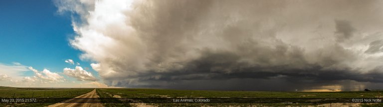
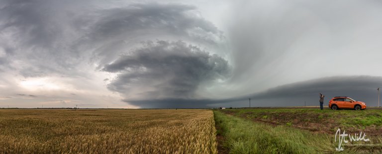
May 23, 2015 – Eastern Colorado

Day one of a three day mini-chasecation as a upper trough was expected to eject into the Plains potentially providing three days of severe weather. The 23rd presented two target areas: Western Texas and Western Oklahoma was characterized by moderate deep layer shear and modest instability while a second target area in Eastern Colorado where a decent area of instability was expected to develop northeast of the surface low, backing low level winds and advecting 50°F dewpoints into the area.

Read more
16 May

May 16, 2015 – Elmer, Oklahoma Tornado

May 16th was the second day of a three day chase. Today a negatively tilted trough was expected to eject over The Plains with a 100kt upper jet poking into the target area. A low pressure in Colorado was progged to shift eastward into Nebraska during the day while a trailing cold front and dryline were expected to surge east across the Texas Panhandle into Oklahoma.

Read more
15 May

May 15, 2015 – Sidney, Nebraska

May 15th and 16th presented a couple of elevated days for severe weather. Despite them probably setting up in Western Nebraska and Southwest Oklahoma/Texas Panhandle area, I decided to make the trek out for the two days. A large trough was working its way through the western CONUS while a weak surface low worked its way across the High Plains into Nebraska. This low would bring with it the enhanced risk for severe weather along a warm front extending across Southern Nebraska as well as along a trailing dryline. Backed low level flow near the low would be the target area.

Read more
10 May

May 10, 2015 – Northern Iowa

May 10th was the last day of my 5 day mini chasecation and although there was an enhanced risk of severe weather along the Missouri River into Iowa, having to work the following day limited how long I could hang out in the target area. Nevertheless, it was on the way home and I may as well give it a shot. SPC had outlined two areas of enhanced risk, along the Missouri River from Sioux Falls through Iowa  and the southern target in Texas near the Dallas-Fort Worth Metroplex.

Read more
09 May

May 9, 2015 – Colorado & Kansas Tornadoes

Day three of a multi-day chase trip featured a mid-level trough that was rotating through the four corners region into the High Plains with a 70-80kt upper jet rounding the base as well. Morning convection made the situation messy for the day and it appeared that two target areas would develop later in the day. The first was in an upslope regime from the OK Panhandle into Colorado; the second along and south of the Red River. I had a bias towards the northern target because I was planning on returning home the following day and I didn’t really want to drive back to Texas after driving to Clinton, OK for the night.

Read more